
GeoAI & Microclimate Forecasting: Shielding Crops from Thailand's Extreme Weather with AI
Use satellite data and Deep Learning to build hyper-local weather prediction systems that help Thai farmers survive unpredictable monsoons and flash floods.
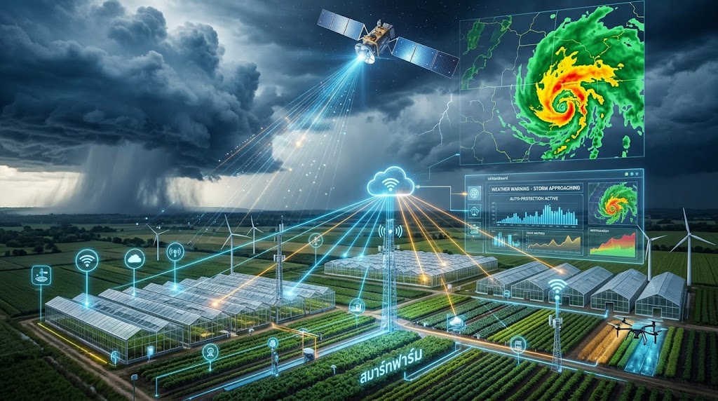
In 2026, natural disasters caused by monsoon variability are heavily damaging Thailand’s agricultural output. This is particularly true in central and northeastern regions facing flash floods and prolonged droughts. This article introduces how GeoAI and Microclimate Forecasting can build farm-level early warning systems.
The Climate Threat to Thai Agriculture
According to the Thai Meteorological Department and Office of Industrial Economics (2025-2026):
- 60% of agricultural areas in central and northeastern Thailand face more severe rainfall variability
- Flash floods destroy crops 30 days before harvest — the highest losses in 10 years
- Prolonged droughts have reduced water in major reservoirs by 40%, impacting irrigation
- Humidity fluctuations trigger severe plant diseases (e.g., rice blast)
“National or provincial weather forecasts are no longer sufficient for farming — we need farm-level resolution.” — KoMoMi Data Science Team
Satellite Data Sources for GeoAI
Building an accurate weather prediction AI requires multi-source data from satellites and ground sensors.
Satellite Data Used
| Satellite | Data | Spatial Resolution | Frequency |
|---|---|---|---|
| THEOS-2 (Thai) | Optical, NIR, SWIR imagery | 2–15 meters | 2-5 days |
| Landsat 8/9 (NASA/USGS) | MSI, Thermal | 30 meters | 16 days |
| Sentinel-2 (Copernicus) | Multi-spectral | 10–60 meters | 5 days |
| MODIS AOD (MCD19A2) | Aerosol Optical Depth | 1 km | Daily |
| GPM IMERG | Precipitation | 0.1° (~11 km) | 30 minutes |
Reanalysis Data (for Training Models)
- ERA5 (ECMWF) — highest-resolution historical weather data globally (0.25°, hourly)
- CMIP6 — climate model data for simulating future scenarios
Satellite Data Processing Pipeline
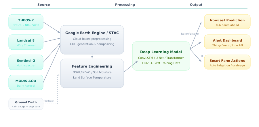
Deep Learning for Weather Nowcasting
Why ConvLSTM?
Rain/weather prediction is a Time Series + Spatial problem — you must understand:
- Temporal dependencies — how the past affects the future
- Spatial correlations — how nearby areas influence each other
ConvLSTM combines both by using convolution instead of matrix multiplication in LSTM gates, preserving spatial structure.
Model Architecture
class PrecipitationNowcaster(nn.Module):
    def __init__(self):
        self.encoder = ConvLSTM2D(
            input_dim=4,      # [rain, temp, humidity, wind]
            hidden_dim=[64, 64, 64],
            kernel_size=(3,3),
            num_layers=3
        )
        self.decoder = ConvLSTM2D(
            input_dim=64,
            hidden_dim=[64, 64, 1],
            kernel_size=(3,3),
            num_layers=3
        )
        self.forecast_steps = 12  # 6 hours ahead (30-min intervals)

    def forward(self, x_seq):
        states = self.encoder(x_seq)
        predictions = []
        prev = x_seq[:, -1]

        for _ in range(self.forecast_steps):
            pred, states = self.decoder(prev, states)
            predictions.append(pred)
            prev = pred

        return torch.stack(predictions, dim=1)
Alternative Architectures
| Model | Use Case | Pros | Cons |
|---|---|---|---|
| ConvLSTM | Short-term rain nowcasting (0-6h) | Great spatial-temporal understanding | Hard to train |
| U-Net + LSTM | Flood prediction | Accurate spatial segmentation | Needs flood mask labels |
| Transformer (Earthformer) | Long-term (7-14 days) | Captures long-range dependencies | High compute needs |
| Graph Neural Network | Farm network forecasting | Understands farm correlations | Requires farm graph |
Translating AI Outputs into Farmer Actions
AI predicting “80% chance of heavy rain in this area within 6 hours” is useless unless farmers know what to do.
KoMoMi Alert System
The system translates AI outputs into easy-to-read Line messages:
🌧️ Heavy Rain Alert — Your Farm (14.5°N, 100.7°E)
━━━━━━━━━━━━━━━━━━━━━
⏰ Forecast: 6:00 PM - 9:00 PM (in 6 hours)
📊 Confidence: 87%
💧 Expected rainfall: 45-65 mm
━━━━━━━━━━━━━━━━━━━━━
✅ Recommendations:
   1. Harvest ripe crops before evening
   2. Turn off automatic irrigation
   3. Ensure drainage systems are open
━━━━━━━━━━━━━━━━━━━━━
📍 Source: GeoAI Model v2.1 + GPM IMERG + THEOS-2
Smart Farm Integration
| GeoAI Forecast | Automatic Action |
|---|---|
| Heavy rain in 6h | Stop irrigation → Open drainage |
| Temperature drop in 12h | Close greenhouse windows → Activate heaters |
| High humidity for 48h | Increase fan speed → Alert disease risk |
| Drought trend for 14 days | Reduce watering frequency → Alert water planning |
Steps to Build a GeoAI System for Your Farm
Phase 1: Data Collection (Week 1-2)
- Register for Google Earth Engine (free for research/education)
- Gather historical data: THEOS-2, Landsat, ERA5 for your farm area
- Collect ground truth: rain gauge readings, crop conditions, yields
Phase 2: Model Training (Week 3-6)
- Preprocess data into time-series spatial arrays
- Train ConvLSTM or Earthformer on Google Colab (GPU) or local GPU server
- Validate with k-fold spatial cross-validation
Phase 3: Deployment (Week 7-8)
- Deploy model on KoMoMi Edge AI Gateway (Pi 5 + Hailo) or AWS/GCP
- Create API endpoint for pulling predictions
- Connect to Line Messaging API or ThingsBoard
Phase 4: Calibration (Ongoing)
- Compare predictions with reality weekly
- Fine-tune with new data (online/transfer learning)
- Adjust alert thresholds based on farmer feedback
Projected Economic Impact
| Metric | Before GeoAI | After GeoAI | Improvement |
|---|---|---|---|
| Flood/drought losses | 25-40% of farm area | 5-10% of farm area | 60-70% reduction |
| Irrigation water cost | ฿15,000/rai/year | ฿10,500/rai/year | 30% savings |
| Watering frequency | 3-4 times/day | 1-2 times/day (AI guided) | 50% reduction |
| Yield | baseline | +15-20% | Revenue increase |
| Labor cost | ฿8,000/month | ฿4,000/month | 50% savings |
Figures based on KoMoMi’s GeoAI + Smart Irrigation trial at a 50-rai durian farm in Rayong, 2025.
The Future of GeoAI in Thai Agriculture
We believe that within 3 years:
- Every medium-sized farm will have its own weather AI
- THEOS-2 satellite data will be opened as Open Data for farmers
- Models pre-trained for Thai climate will be available — no training from scratch needed
- Federated Learning across multiple farms will create more accurate models without sharing sensitive data
KoMoMi invites all farms interested in GeoAI and Microclimate Forecasting to collaborate. Whether your farm is small or large, we have suitable solutions for every scale.
If you’re a farm interested in hyper-local weather prediction, or a data science team looking to develop models for Thai agriculture, contact KoMoMi today.